Key Takeaway
The Yucatán Peninsula contains an estimated 6,000+ cenotes — natural sinkholes formed by the collapse of porous limestone bedrock, exposing the vast underground river system below. For the Maya, cenotes were far more than water sources. They were sacred portals to Xibalba — the underworld — and sites where offerings of jade, gold, pottery, copal incense, and human life were made to the gods who controlled rain and fertility.
Geology: How Cenotes Form
The Yucatán Peninsula sits on a massive platform of Cretaceous and Tertiary limestone — porous rock that absorbs rainfall rather than channeling it into surface rivers. Over millions of years, slightly acidic rainwater dissolves the limestone, creating an underground network of caves, tunnels, and rivers. When the roof of a cavern weakens and collapses, the result is a cenote — a natural well exposing the aquifer below.
This geological process was dramatically accelerated in the Yucatán by the Chicxulub impact crater — the 180-kilometer-wide crater left by the asteroid that caused the Cretaceous-Paleogene mass extinction 66 million years ago. The fracture ring created by the impact created a zone of enhanced permeability, resulting in a distinctive "ring of cenotes" that traces the crater's buried rim (Perry et al., Geology, 1995).
Types of Cenotes
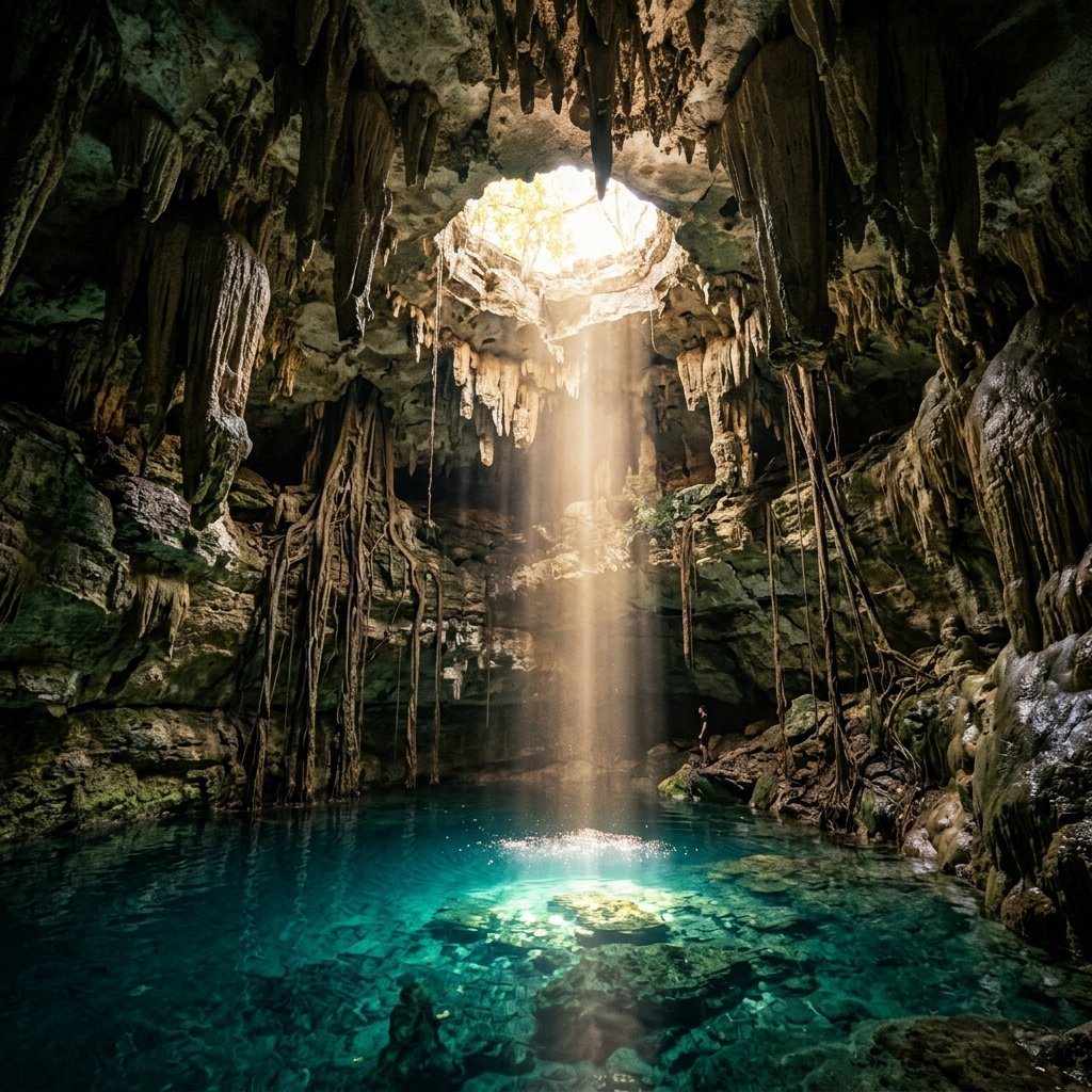
- Open cenotes — fully collapsed, open-air pools (e.g., Sacred Cenote at Chichén Itzá)
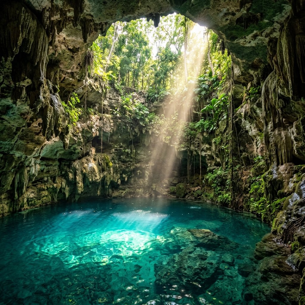
- Semi-open cenotes — partially collapsed, with cave overhangs (e.g., Cenote Ik Kil)
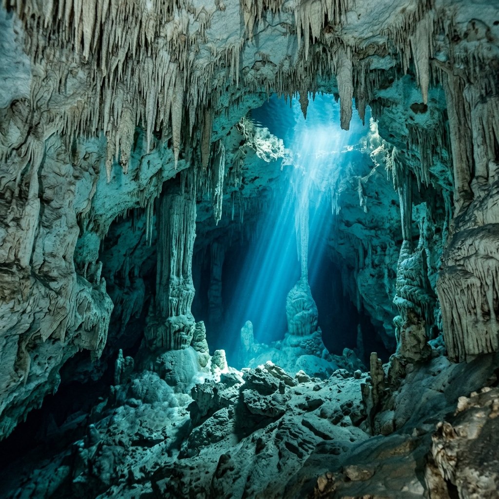
- Cave cenotes — accessed through cave entrances, mostly underground
- Pit cenotes — vertical-walled sinkholes with steep drops to water
Key Statistics
- ~6,000+ cenotes identified in the Yucatán
- ~10,000 estimated total (many still undiscovered)
- Depth range: 5m to 119m (Cenote Zacatón, deepest)
- Water temperature: typically 24–26°C year-round
- Water clarity: up to 100m visibility in cave systems
Sacred Significance
The Maya word for cenote is ts'onot (Yucatec) or ch'en (Classic Maya), and cenotes occupied a central place in cosmology. The Maya conceived of cenotes as openings to Xibalba — the watery underworld ruled by the lords of death, where the Hero Twins descended for their mythic trials.
Maya cities were frequently built around or near cenotes, which served a dual purpose: practical freshwater supply and sacred ritual center. The great city of Chichén Itzá takes its name from cenotes — Chi ch'en Itza, meaning "at the mouth of the well of the Itza [people]."
The Sacred Cenote at Chichén Itzá
The most archaeologically significant cenote is the Cenote Sagrado (Sacred Cenote) at Chichén Itzá — a roughly circular sinkhole 60 meters in diameter with sheer walls dropping 27 meters to the water surface. It was a major pilgrimage site dedicated to Chaac, the rain god.
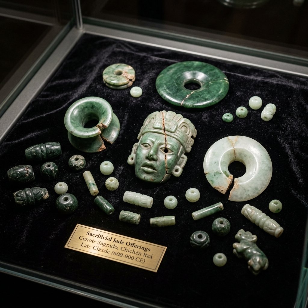
- Jade: earflares, beads, pendants, plaques, and carved figurines — many deliberately broken ("killed") before offering
- Gold: discs, bells, and ornaments — many of non-local origin, indicating long-distance trade networks reaching as far as Panama and Colombia
- Ceramics: incense burners and vessels coated in Maya Blue pigment
- Copal incense: shaped into heart-like forms before casting into the water
- Human remains: skeletal analysis identified remains of both adults and children, with some showing signs of perimortem trauma consistent with sacrifice (Anda Alanís, Latin American Antiquity, 2007)
Underwater Archaeology
Since the 1990s, cave-diving archaeologists have explored submerged cave systems connected to cenotes, making remarkable discoveries in the process. These underwater sites preserve organic materials — wood, fiber, bone — that rarely survive in above-ground tropical conditions.
One of the most significant finds came from the Hoyo Negro cenote in Quintana Roo, where in 2007, divers discovered the nearly complete skeleton of a teenage girl — named "Naia" — dating to approximately 12,000–13,000 years ago. DNA analysis confirmed her as genetically related to modern Native Americans, helping resolve debates about the peopling of the Americas (Chatters et al., Science, 344, 2014).
Other cenote discoveries include Pleistocene megafauna remains (giant ground sloths, gomphotheres, saber-toothed cats), Ancient Maya canoes preserved in the anaerobic environment, and ceramic vessels still containing organic residues analyzable by modern chemistry (Suárez Díez, Archaeometry, 2019).
Cenotes and Water Management
In a region with no surface rivers, cenotes were the lifeline of Maya civilization. Cities that controlled access to cenotes controlled survival itself. Archaeological evidence shows that the Maya modified cenotes extensively:
- Built stone staircases and carved access paths into cenote walls
- Constructed reservoirs (chultunes) to collect rainwater and supplement cenote supply
- Channeled water from cenotes to irrigate raised agricultural fields
- Protected cenotes with walls and restricted access — indicating centralized control by elites
Research by archaeologist Lisa Lucero has proposed that elite control of water resources — particularly cenotes and reservoirs — may have been a primary driver of political authority in the Maya lowlands, and that the loss of reliable water access during prolonged droughts contributed to the Classic Maya Collapse (Lucero, Latin American Antiquity, 2002).
Visiting Cenotes Today
Many cenotes in the Yucatán are now open for swimming, snorkeling, and cave diving, making them among the most popular attractions in the region. The crystal-clear water, dramatic cave formations, and shafts of sunlight create an environment of extraordinary natural beauty.
Frequently Asked Questions
How many cenotes are there in the Yucatán?
Approximately 6,000 cenotes have been officially catalogued in the Yucatán Peninsula, but geologists estimate there may be over 10,000 — many still hidden beneath jungle vegetation or sealed by thin rock layers. New cenotes are regularly discovered during construction, farming, and geological surveys.
Did the Maya really sacrifice people in cenotes?
Yes — human remains with evidence of perimortem trauma have been recovered from several cenotes, most notably the Sacred Cenote at Chichén Itzá. However, not all cenotes were sacrificial sites, and the frequency and scale of human sacrifice varied by period and region. Many cenote offerings were non-human: jade, gold, pottery, incense, and food.
Is it safe to swim in cenotes?
Many cenotes in the Yucatán are open for swimming and snorkeling, with infrastructure including stairs, life jackets, and guides. The water is generally very clean (naturally filtered through limestone) and maintains a comfortable temperature year-round. Cave diving in cenote systems requires specialized certification and equipment.
References & Further Reading
- Perry, E., et al. (1995). "Ring of Cenotes (sinkholes), northwest Yucatan, Mexico: its hydrogeologic characteristics and possible association with the Chicxulub impact crater." Geology, 23(1), 17–20.
- Chatters, J. C., et al. (2014). "Late Pleistocene Human Skeleton and mtDNA Link Paleoamericans and Modern Native Americans." Science, 344(6185), 750–754. doi:10.1126/science.1252619
- Anda Alanís, G. de (2007). "Sacrifice and Ritual Body Mutilation in the Sacred Cenote of Chichén Itzá." Latin American Antiquity, 18(4), 399–418.
- Lucero, L. J. (2002). "The Collapse of the Classic Maya: A Case for the Role of Water Control." American Anthropologist, 104(3), 814–826.
- Coggins, C. C. & Shane, O. C., eds. (1984). Cenote of Sacrifice: Maya Treasures from the Sacred Well at Chichén Itzá. UT Austin Press.