Key Takeaway
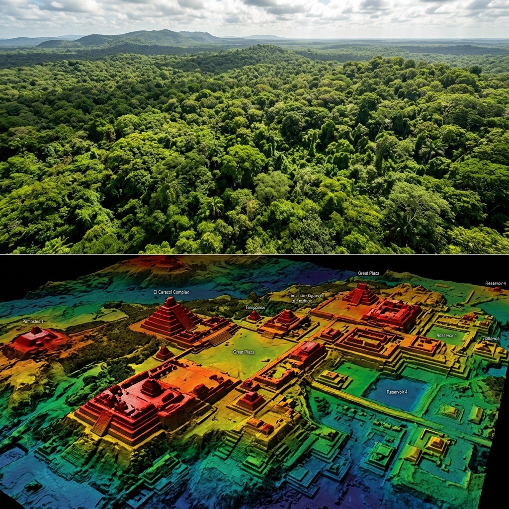
LiDAR (Light Detection and Ranging) technology fires laser pulses from aircraft that penetrate jungle canopy and bounce off the ground below, creating detailed 3D terrain maps. Applied to the Maya lowlands since 2009, LiDAR has revealed that the ancient Maya built on a scale far exceeding previous estimates — with millions of structures, extensive road networks, and massive water management systems hidden beneath centuries of forest regrowth.
The Technology
Airborne LiDAR works by mounting a laser scanner on an aircraft that flies over a target area. The scanner fires up to 500,000 laser pulses per second toward the ground. Most pulses hit the tree canopy, but a percentage penetrate gaps in the foliage and reach the forest floor. By measuring the time it takes for each pulse to return, the system builds a precise three-dimensional model of the terrain — effectively "seeing through" the jungle.
The resulting data can be processed to remove all vegetation digitally, producing a "bare-earth" model that reveals archaeological features invisible from the surface or even from satellite imagery. For Maya archaeology — where most ancient cities are buried under dense tropical forest — this technology has been transformative.
The 2018 Guatemala Survey
The landmark study, published in Science in September 2018 by Canuto, Estrada-Belli, Garrison, and colleagues as part of the PACUNAM LiDAR Initiative, surveyed 2,144 km² of the Petén region in northern Guatemala — the heartland of Classic Maya civilization.
The results exceeded all expectations. The survey identified:
"LiDAR has shown that the Maya lowlands were a densely occupied landscape, comparable in scale and complexity to the ancient civilizations of China or Southeast Asia."
— Canuto et al., Science 361(6409), 2018
What LiDAR Has Revealed
Massive Agricultural Systems
One of the most significant findings is the extent of Maya agricultural modification of the landscape. LiDAR revealed thousands of previously unknown raised fields, terraces, irrigation channels, and wetland management features — evidence that the Maya transformed their environment far more intensively than the "slash-and-burn" model long assumed by scholars.
At El Mirador in the Petén, LiDAR identified a network of causeways connecting a constellation of Preclassic cities (circa 600 BC–150 AD) — suggesting large-scale political organization centuries earlier than previously believed (Hansen et al., Cambridge Archaeological Journal, 2023).
Defensive Fortifications
LiDAR uncovered extensive defensive works — walls, ditches, and ramparts — around many Maya cities, challenging the long-held view that the Classic Maya were a predominantly peaceful, ceremonial civilization. The evidence suggests that warfare was more organized, more frequent, and more destructive than decades of field archaeology had indicated.
The fortification systems around Tikal and its rival Calakmul revealed by LiDAR suggest these were not isolated city-states but militarized territorial powers controlling large hinterlands — a political model closer to medieval European kingdoms than the small chiefdoms some scholars had proposed.
Road Networks (Sacbeob)
The Maya built sacbeob (literally "white roads") — raised limestone causeways that connected cities, temples, and resource areas. Previous ground surveys had identified a few dozen segments. LiDAR revealed that these roads were part of an interconnected regional transportation network stretching hundreds of kilometers across the lowlands.
Earlier LiDAR Discoveries
The 2018 survey was not the first use of LiDAR in Maya archaeology. Earlier studies laid the groundwork:
Implications for Maya Studies
The cumulative impact of LiDAR on Maya archaeology has been compared to the effect of the Hubble Space Telescope on astronomy: it has not merely added detail — it has revealed that the subject of study is fundamentally larger and more complex than previously understood.
Key revisions to our understanding include:
- Population: Estimates of peak Maya population have been revised upward from 1–2 million to 7–11 million people in the lowlands alone — far larger than contemporary medieval European cities
- Agriculture: The Maya landscape was not "virgin forest" during the Classic Period but a heavily managed, intensively farmed environment — undermining romantic narratives about the Maya living "in harmony" with untouched nature
- Urbanization: Many areas previously classified as "rural hinterland" between major cities were, in fact, continuous low-density urban sprawl — a settlement pattern that archaeologist Roland Fletcher has compared to modern cities like Los Angeles
- Warfare: Defensive infrastructure visible in LiDAR confirms that Maya warfare was organized, territorial, and devastating — consistent with hieroglyphic records of "star wars" (total-destruction campaigns) between rival city-states
Limitations and Ongoing Work
LiDAR is not a magic bullet. Important limitations include:
- LiDAR identifies features, not dates — ground verification through excavation is still needed to determine when structures were built and used
- Not all structures identified by LiDAR are confirmed as human-made — natural rock formations can sometimes mimic architectural features
- LiDAR surveys remain expensive (approximately $10,000–$50,000 per survey block), limiting coverage
- Only a fraction of the total Maya area (estimated at 250,000+ km²) has been surveyed — what remains hidden may dwarf what has been found
Frequently Asked Questions
How many Maya structures are still undiscovered?
Based on the densities found in LiDAR-surveyed areas (roughly 100+ structures per km²), and extrapolating across the estimated 250,000+ km² of the Maya lowlands, the number of undiscovered structures could be in the tens of millions. Archaeologist Thomas Garrison has estimated that "less than 5% of Maya sites have been mapped, let alone excavated."
Did LiDAR find any completely unknown cities?
Yes. Several previously unknown urban centers have been identified purely through LiDAR, particularly in remote areas of the Petén jungle and the Mosquitia region of Honduras. Many of these sites have yet to be reached on foot, let alone excavated — they remain "invisible cities" known only through laser data.
Why didn't archaeologists know about these structures before?
Dense tropical jungle is extremely difficult to survey on foot. A ground survey team might spend weeks mapping a single temple complex, while LiDAR can cover 2,000+ km² in hours. Many structures are also relatively small (house platforms, terraces, walls) and are invisible under undergrowth. The sheer scale of what was hidden simply could not have been detected by traditional methods.
References & Further Reading
- Canuto, M. A., Estrada-Belli, F., Garrison, T. G., et al. (2018). "Ancient lowland Maya complexity as revealed by airborne laser scanning of northern Guatemala." Science, 361(6409), eaau0137. doi:10.1126/science.aau0137
- Chase, A. F., Chase, D. Z., & Weishampel, J. F. (2012). "Lasers in the Jungle: Airborne sensors reveal a vast Maya landscape." Proceedings of the National Academy of Sciences, 109(32), 12916–12921. doi:10.1073/pnas.1205198109
- Hansen, R. D., et al. (2023). "LiDAR analyses in the contiguous Mirador-Calakmul Karst Basin, Guatemala." Cambridge Archaeological Journal, 33(4), 657–683.
- Garrison, T. G., et al. (2019). "Evaluating the use of ALOS PRISM imagery for mapping ancient Maya features in northwestern Peten, Guatemala." Journal of Archaeological Science: Reports, 24, 207–215.
- Fletcher, R. (2009). "Low-Density, Agrarian-Based Urbanism." In: The Cambridge World History, Vol. 3. Cambridge University Press.
- Inomata, T., et al. (2020). "Monumental architecture at Aguada Fénix and the rise of Maya civilization." Nature, 582, 530–533. doi:10.1038/s41586-020-2343-4