The Bottom Line
LiDAR surveys across Mesoamerica and beyond have uncovered evidence that pre-Columbian American societies were far larger, more organized, more interconnected, and more environmentally transformative than the traditional archaeological model suggested. The technology hasn't just added data — it has challenged foundational assumptions about social complexity, population density, and what it means for a civilization to be "advanced."
The Assumption That Died
For most of the 20th century, the popular (and, let's be honest, the scholarly) image of pre-Columbian Americans went something like this: small groups of people living lightly on the land, building the occasional impressive pyramid but never achieving the urban scale of Rome, Athens, or Chang'an. The jungle? Pristine wilderness. The hinterlands between major ceremonial centers? Empty.
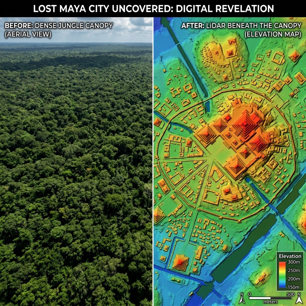
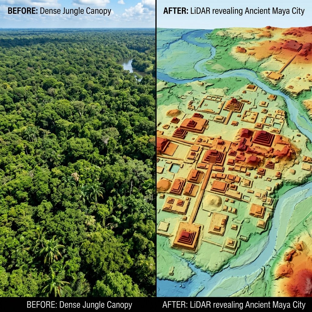
LiDAR killed that narrative in about 72 hours.
When the PACUNAM LiDAR Initiative published its 2018 results in Science, it revealed 61,480 previously unknown structures across 2,144 km² of Guatemala's Petén region. Not temples and pyramids — those we already knew about. Houses. Farms. Walls. Roads. Reservoirs. Infrastructure. The stuff of a functioning society with millions of members (Canuto et al., Science, 361, 2018).
What the Data Actually Shows
What We Assumed
- Scattered city-states surrounded by "empty" jungle
- Population of 1–2 million in the Maya lowlands
- Slash-and-burn agriculture (inefficient, small-scale)
- Limited road networks; isolated communities
- Warfare was ritualistic and limited
What LiDAR Found
- Continuous low-density urbanization — suburbs, not jungle
- Revised population of 7–11 million
- Massive terracing, raised fields, and canal irrigation
- 362+ km of engineered causeways connecting cities
- Extensive defensive fortifications — walls, ditches, ramparts
Beyond the Maya: Other LiDAR Revelations
The Maya lowlands are not the only region where LiDAR has rewritten history:
Angkor Wat, Cambodia
LiDAR surveys in 2012–2015 revealed that Angkor was not a collection of temples in a jungle clearing but the largest pre-industrial city on Earth — a low-density urban sprawl covering 1,000+ km² with sophisticated water management infrastructure (Evans et al., PNAS, 2013). Sound familiar? The parallel with the Maya discoveries is striking and may reflect a common pattern for tropical civilizations.
Amazon Basin
LiDAR and satellite surveys have revealed hundreds of geometric earthworks (geoglyphs) in the western Amazon, some predating European contact by 2,000+ years. The Amazon — long assumed to be "virgin forest" — was home to complex societies that reshaped the landscape on a massive scale (de Souza et al., Nature Communications, 2018). The forest itself may be partly an artifact of ancient human cultivation.
Aguada Fénix, Mexico
In 2020, LiDAR revealed the largest and oldest known Maya structure — a 1.4-km-long ceremonial platform at Aguada Fénix, Tabasco, dating to approximately 1000 BC. This is older than any known Maya pyramid and was built by people who may not yet have had permanent social hierarchies (Inomata et al., Nature, 582, 2020). It challenges the assumption that monumental construction requires class-stratified states.
Why This Matters Beyond Archaeology
Here is where it gets genuinely provocative:
1. The "Primitive Americas" Myth Was Always Political
The narrative of the Americas as a lightly populated wilderness was not just a scientific error — it was a politically convenient one. The doctrine of terra nullius ("nobody's land") was used to justify European colonization. If the Americas were presented as containing only scattered "primitive" peoples, their dispossession could be framed as benign or inevitable.
LiDAR data makes that narrative untenable. These were not small chiefdoms in a vast empty forest — they were continental-scale civilizations that were devastated by European-borne epidemics (which killed an estimated 90% of the indigenous population in the 16th century) and then rendered invisible as the jungle reclaimed their cities (Koch et al., Quaternary Science Reviews, 2019).
2. Religious Texts Describe Exactly This
It's worth noting — without making a faith claim — that both the Book of Mormon and the Popol Vuh describe the Americas as home to large, organized, literate civilizations that built cities, kept records, and waged wars of extraordinary scale. For most of the 20th century, these descriptions seemed inconsistent with the archaeological evidence. LiDAR has significantly narrowed that gap.
3. What Else Is Hiding?
Only a fraction of the total Maya area has been surveyed by LiDAR. Vast stretches of the Petén, Campeche, Quintana Roo, Belize, and western Honduras remain unscanned. If the densities found in surveyed areas are representative, the total number of undiscovered structures in Mesoamerica alone could be in the tens of millions. And that's just Mesoamerica — the Amazon, Southeast Asia, Central Africa, and the Indian subcontinent all contain forested regions where complex societies may have existed and vanished from view.
"The truth is, we've been doing archaeology with our eyes half shut. LiDAR opened them. And what we're seeing should make us very humble about what we think we know."
— Thomas Garrison, archaeologist, National Geographic Explorer
Frequently Asked Questions
Could there be an undiscovered civilization hidden under the jungle right now?
That's not even hypothetical anymore — it's happened multiple times. LiDAR revealed an entire road network around Tikal that field archaeologists working at the site for 60 years had never detected. Aguada Fénix, the largest Maya structure ever found, was identified in 2020 — by LiDAR, in a region that had been farmed for decades. The question isn't whether there are more undiscovered civilizations. The question is how many.
Does this change what we think about ancient American capabilities?
Fundamentally, yes. The engineering required to build 362 km of raised causeways through swampland, construct reservoirs holding millions of liters, and feed 7–11 million people using intensive agriculture in tropical conditions requires organizational capacity, mathematical knowledge, and engineering skill comparable to contemporary Old World civilizations. The Maya weren't a sideshow of world history — they were a main event.
References & Further Reading
- Canuto, M. A., et al. (2018). "Ancient lowland Maya complexity as revealed by airborne laser scanning." Science, 361(6409), eaau0137.
- Evans, D. H., et al. (2013). "Uncovering archaeological landscapes at Angkor using lidar." PNAS, 110(31), 12595–12600.
- de Souza, J. G., et al. (2018). "Pre-Columbian earth-builders settled along the entire southern rim of the Amazon." Nature Communications, 9, 1125.
- Inomata, T., et al. (2020). "Monumental architecture at Aguada Fénix." Nature, 582, 530–533.
- Koch, A., et al. (2019). "Earth system impacts of the European arrival and Great Dying in the Americas." Quaternary Science Reviews, 207, 13–36.
- Fletcher, R. (2009). "Low-Density, Agrarian-Based Urbanism." In: The Cambridge World History, Vol. 3.